| |
| Big
Desert Wilderness |
 |
This
vast wilderness area of 113,500 hectares features a diverse
and complex landscape. Home to a wide variety of birds, reptiles
and mammals, it offers visitors an opportunity to experience
a landscape which has remained unaffected by human beings
It is reputed to be the best single area in Victoria for reptiles,
with over 50 species of lizards and snakes. The park also
provides a challenge for the experienced bushwalker.
Things to see and do
Walk through a true wilderness. The park is a truly rewarding
area for birdwatching and nature study, where a great variety
of birds, reptiles and small mammals make their home.
Camping & Facilities
No facilities or water are provided in the park. There are
some campsites provided nearby at Big Billy Bore, the Springs,
Moonlight Tank and Broken Bucket Reserve along the Nhill-Murrayville
Road. Bore water is available at Big Billy Bore and Broken
Bucket Reserve and there are toilets at Broken Bucket.
Heritage
Europeans have left the Big Desert largely untouched since
their arrival due to the inhospitable nature of the area.
The Big Desert is Victoria's first declared wilderness area.
It is a vast park of 113,500 hectares and adjoins large conservation
areas in South Australia.
Flora and Fauna
Native vegetation is mainly heath, mallee heath and scrub
mallee growing in infertile sands. The heath and mallee heath
contain a wide variety of shrubs such as desert banksia, scrub
cypress pine, grass tree, she-oak, tea-trees and heaths. The
more prominent shrubs in the scrub mallee are scrub cypress
pine, broom heath-myrtle, broombrush and tea-trees.
The region is considered to be the best single area in Victoria
for reptiles with over fifty species of lizards and snakes
recorded. Ninety-three species of birds have been recorded
in the park including the extremely rare western whipbird.
Mammals found in the area include the silky mouse, western
pygmy possum and Mitchell's hopping-mouse.
Looking after the park
Use a small camping stove rather than a fire. No fire may
be lit on a day of total fire ban. Take your rubbish home
with you. Dogs, cats and other pets are not permitted in the
wilderness. Firearms are not permitted in the wilderness.
All native plants and animals are protected - no specimens
may be removed. To minimise your impact on the wilderness
use a small camping stove.
Precautions
You must carry your own water. Temperatures in summer are
far too high for safe and comfortable walking. Before leaving
on an overnight walk, please inform the ranger at Wyperfeld
National Park.
How to get there
There are no tracks into the park. The best approach is by
walking from the Nhill-Murrayville Road, which is separated
from the park by a 5km strip of public land. The Nhill-Murrayville
Road is a dry weather road only and may be rough in places.
For more information on the Big Desert Wilderness, call the
Parks Victoria Information Line on 13 1963 or visit Parks
Victoria's website on www.parks.vic.gov.au
Click
Here to View Map
|
| Grampians
National Park |
|
|
The
spectacularly rugged mountain ranges and stunning wildflower
displays of the Grampians National Park provide some of
the most magnificent scenery in the country. The 167,000
hectare park was established in 1984 and is comprised of
four main ranges: Mt William, Sera, Mt Difficult and Victoria
Range. Rising to heights of over 1000 metres, they form
the western edge of the Great Dividing Range.
The park is home to almost a third of Victoria's plant species.
It's colourful display of wildflowers and abundant wildlife
make it a natural wonderland.
Another great feature of the park is the presence of Aboriginal
Rock Art sites. Aboriginal people camped and painted images
of their life and law on the sandstone walls. About 60 known
sites have been located throughout the ranges, although
only a number are publicised for visiting. The best way
to explore the Aboriginal cultural heritage and local rock
art sites is to start with a visit to the exciting Brambuk
Aboriginal Cultural Centre.
Things
to see and do
The Grampians National Park is a wonderful place for bushwalking,
camping, fishing, rockclimbing and a host of other outdoor
activities and is also a great place for scenic drives.
There are over 160kms of walking tracks from short strolls
to challenging overnight expeditions for experienced bushwalkers.
Heritage
Aboriginal occupation of the Grampians dates back beyond
10,000 years and the area contains the majority of Aboriginal
rock art sites in south-east Australia. In 1836, the NSW
Surveyor-General, Sir Thomas Mitchell, named the ranges
after mountains in his native Scotland. Graziers soon followed,
attracted to the picturesque settings, while the region
has also seen gold mining, quarrying and timber industries
take hold.
Flora
and Fauna
The stunning spring wildflower displays, best seen in October,
are the outstanding feature of the park's flora but the
vast array of over 800 indigenous plants is equally interesting.
The vegetation ranges from stunted heaths to stringybark
forests, redgum woodlands and luxuriant fern gullies.
Kangaroos, possums, gliders, echidnas and koalas are common,
while nearly 200 species of bird life inhabit the park.
Zumstein picnic ground is a popular kangaroo viewing area.
Koorie Heritage
While
Aboriginal rock paintings are rare in Victoria and Australia
they are not in the Grampians National Park. Five thousand
years ago, the Koories who roamed the well stocked hunting
ground surrounding Gariwerd as the mountain range was known
to them, began recording their dreamtime legends and ceremonies
on the recessed walls of caves, tucked away in rocky outcrops.
It is a record of an ancient culture which was virtually
destroyed with the arrival of European settlers.
Because these mountains provided a rich source of food and
water, Koories were freed from spending long hours hunting
and gathering. Spare time was dedicated to cultural activities,
of which evidence may be seen today. Over 100 caves have
been found where the rock faces are decorated by fine examples
of Koorie art. You can visit about 10 shelters.
Nearly 4000 different art motifs have been recorded, although
the major designs are emu tracks, human figures, hands,
bars and straight lines. The oldest hand stencils are over
2000 years old, while the most recent where painted around
the time Europeans discovered Australia.
Today, the Brambuk Living Cultural Centre, just two kilometres
from Halls Gap, brings to life the rich history and culture
of the Koorie communities of the Wimmera and south west
Victoria. From a stone chimney, atop the Brambuk Centre,
smoke lazily drifts upward, in a way reminiscent of a campsite
fire. Inside there are rare displays of traditional Koorie
art, clothing, weapons and tools. On the ceremonial ground
you can experience traditional music, dance and cooking.
Sample bush tucker Koorie style. Or let the people whose
ancestors created this culture take you on an informed tour
of the Koorie rock art sites.
A 70 kilometre drive south west of The Grampians National
Park, at Lake Condah, is another significant Koorie site.
Here you can see fish traps made from local basalt rock.
The Koorie tribes relied on the rise and fall of the level
of the lake to trap the fish. Around the traps you'll find
the remains of more than 200 semicircular shaped stone houses
which date back between 200 and 6000 years. Unlike most
Koories, the tribe in this area had relatively permanent
homes.
Nearby is the Lake Condah Aboriginal Mission, built by Europeans
in 1867. Take a walk around the mission, through the ruins
of the Mission House, bluestone cottages and the site of
St. Mary's Church.
Sixty kilometres north of The Grampians National Park is
Antwerp. Here you'll find The Ebenezer Mission station which
today stands in ruins. Its pale pink stone buildings are
surrounded by wheatfields and bush. A tiny cemetery contains
graves of Mission Koories and Lutheran priests. An Antwerp
Koorie, Bobby Kinnear, who won the rich Stawell Gift footrace
in 1883, is buried here. His grave is marked by a Koorie
monument erected in 1985 by the Goolum Goolum Aboriginal
Co-operative to remember local Koories.
Another well known Koorie from Western Victoria was Johnny
Mullagh. He was a famous cricketer from Harrow, who played
with the first Koorie cricket team to visit England, in
1868. His memorial stands in the tiny village of Harrow,
70 kilometres west of the Grampians National Park.
How
to get there
The 260 km drive from Melbourne along the Western or Glenelg
Highways takes about 3.5 hours. There are approaches to
Halls Gap (Vic Roads Touring Guide 56-A4) via Stawell, Horsham,
or Dunkeld.
For more information on Grampians National Park, including
facilities, camping, walking, and scenic drives, call the
Parks Victoria Information Line on 13 1963 or visit Parks
Victoria's website on www.parks.vic.gov.au
Click
Here to View Map
|
| Langi
Ghiran State Park |
|
|
There
are two distinct land types in this 2695ha park- rugged
granite peaks and gentle sloping open woodland.
Things to see and do
The park offers the visitor the opportunity for walking,
driving and exploring in a relatively unspoiled area. There
is a small picnic site among Candlebark Gums at the end
of Kartuk Road, the main visitor access road.
Camping & Facilities
Car-based camping is restricted to the camp area at the
end of Kartuk Road. Remote dispersed camping is permitted
in the mountainous section of the Park. Camping beside Hidden
Lagoon between the two peaks is popular. Please use minimal
impact camping practices. Camp fees do not apply.
Langi Ghiran picnic and camping area provides toilets, fireplaces,
tables, information and water.
Walking
An attractive walk showing many historic and natural features
of the Park begins from the picnic ground along Easter Creek
to the old Langi Ghiran Reservoir, then along the stone
water race to a scenic lookout. In the southeast of the
Park, the Lar-ne-Jeering Walking Track leads to an Aboriginal
shelter displaying art unique to the area. There are opportunities
for 'off track' walking in the mountainous section.
Driving
A drive along Langi Ghiran Track will reveal a variety of
vegetation types and landforms.
Heritage
There is a great deal of evidence that Aboriginal people,
the Ngutuwul balug or "mountain people" of the Dwab wurrung
tribe, occupied this area. Four rock art sites, numerous
shelters, scar trees and other artifacts have been recorded
in the Park.
Major Thomas Mitchell climbed Mount Langi Ghiran, which
he named Mount Mistake, on his 1836 'Australia Felix' expedition.
The River Red Gum - Yellow Box open woodland was grazed
by domestic stock from the early days, and is now recovering
from this past use. Small mining and timber industries have
also been part of the landscape however despite all the
recent human activity, the park retains an unspoiled atmosphere
which rewards the visitor with it's feeling of remoteness.
Flora & Fauna
River Red Gum and Yellow Box trees are scattered throughout
the woodland while Messmate, Manna Gum and Red Stringybark
inhabit the mountainous section of the Park. Yarra Gum and
Manna Gum line the watercourses and Shiny Tea-tree, Veined
Beard-heath and Langi Ghiran Grevillea occupy the higher
peaks.
Eastern Grey Kangaroos inhabit the woodland and can often
be seen from the roads. Echidnas, wallabies and a variety
of birds are found throughout the Park. Powerful Owls inhabit
the northern and eastern slopes and Wedge-tailed Eagles
are often seen soaring the higher peaks.
Looking after the park
Help look after this Park by remembering these guidelines:
All wildlife and native plants are protected. Fires may
be lit only in fireplaces provided. No fires may be lit
on Total Fire Ban days. Dogs, cats and firearms are not
permitted. Please take your rubbish home. Remain on walking
tracks where applicable to avoid damaging vegetation. Practice
minimal impact camping in the remote sections of the Park.
Horseriding is not permitted in the Park.
Precautions
Walkers should be aware that there is no water in most of
the Park in the drier months so you must bring your own.
How to get there
Langi Ghiran State Park is situated adjacent to the Western
Highway 195 km west of Melbourne and 14 km east of Ararat.
Kartuk Road provides the main access into the Park. Melway
Ref. 526 G3P. Vicroads Country Directory reference; Map
57, C7. Nearby Parks Grampians National Park. Mount Buangor
State Park. Kara Kara State Park. Paddys Ranges State Park
For more information on Langi Ghiran State Park call the
Parks Victoria Information Line on 13 196 or visit Parks
Victoria's website on www.parks.vic.gov.au
|
| Little
Desert National Park |
|
|
Situated
375 km north-west of Melbourne, Little Desert National Park
is a desert in name only. The three blocks of the park have
a rainfall range of 400 mm per year in the north-east to
600 mm in the south-west. Taking a campsite along the Wimmera
River with it's fringed banks of River Red Gums and chirping
birdsongs of the Reed Warblers, are part of what make this
park a national treasure. One of the best times to visit
the park is between late winter and early summer when the
temperatures are comfortable and the park is full of blossoms
and wildflowers. The eastern block is the most accessible.
Things
to see and do
Almost 600 km of tracks criss-cross all three blocks of
the park, giving access to even the most remote areas near
the South Australian border. Most tracks are too sandy for
two-wheel drive vehicles but good signposting makes the
park ideal for four-wheel driving.
One of the best ways to see the Little Desert National Park
is on foot. There are three interesting self-guided walks
in the eastern block: the Sanctuary nature walk south of
Kiata, Stringybark walk south of Nhill on the Gymbowen Road,
and at the Dimboola end, a short nature walk to Pomponderoo
Hill. From the camping ground south of Kiata, walking tracks
lead to a variety of places of interest. An area quite different
from the rest of the park can be seen by strolling along
the banks of the Wimmera River, or on the walking track
at Ackle Bend. Long distance walkers can tackle all or part
of the 84 km Desert Discovery Walk, where options of one
to four days duration are possible.
Camping
& Facilities
Basic facilities (fireplaces, tables and toilets) are provided
at park camping grounds south of Kiata, and at Horseshoe
Bend and Ackle Bend south of Dimboola. A fee applies to
campers at these campgrounds. Vehicle-based camping away
from the park camping grounds is permitted in the central
and western blocks.
Heritage
In 1955, the Kiata Lowan Sanctuary was created. This was
the first area of the Little Desert to be reserved, when
217 ha were set aside for the preservation of the Mallee
Fowl. The area was increased to 945 ha in 1968 and declared
as the Little Desert National Park. In December 1969 the
area of the Park was increased to 35,300 ha. and by 1988
the park had increased in size to an area of 132,000 ha
with the addition of the central and western blocks to the
existing eastern block. The park now extends from the Wimmera
River in the east to the South Australian border.
Flora
& Fauna
More than 670 species of native plants have been recorded
in the Little Desert, representing about one fifth of Victoria's
indigenous flora. The eastern block contains extensive heathlands,
with banksia, tea-tree and sheoak, and many spring flowering
species. Woodlands of Yellow and Red Gum with Slender Cypress-pines,
and swamps and clay flats of Bull-oak and melaleuca are
of particular interest in the western block. The central
block contains elements of the vegetation types of both
the other blocks, with extensive areas of stringybark. Three
plant species are considered rare or significant. Scattered
throughout sandy areas of the park are ridges of iron-rich
sandstones on which Broombush can be found
Apart from the elusive Mallee Fowl and rare Southern Scrub
Robin, more than 220 kinds of birds have been seen. Parrots,
wrens and currawongs are common, and honeyeaters feed on
the flowering plants. Animal life includes Brushtailed Possums
and Sugar Gliders, kangaroos, bats and many kinds of reptiles.
Stumpy-tailed Lizards and Bearded Dragons are often found
basking in the sun.
Looking
after the park
All native plants and animals are protected. Fires may only
be lit in fireplaces provided. No dogs or cats. No firearms,
generators or chainsaws. Vehicles may only be driven on
roads open to the public. Please take your litter home with
you.
Precautions
During certain times of the year, some tracks may be
closed to vehicles. Tracks in the western and central blocks
are unsuited to two wheel drive vehicles. Carry water with
you, as supply is limited.
How
to get there
Little Desert National Park is 375 km from Melbourne, between
the Wimmera River and the South Australian border (Melway
519 H9). A number of bitumen roads lead to the park from
the Western Highway. The western and central blocks may
be approached from Kaniva, the central and eastern blocks
from Nhill and Kiata, and a good gravel road leads to the
Wimmera River section of the eastern block from Dimboola.
Similarly, bitumen road access is possible from the south
via Mitre, Gymbowen, Goroke, and Edenhope or Booroopki.
For more information on Little Desert National Park, including
details in walks and camping within the park, call the Parks
Victoria Information Line on 13 1963 or visit Parks Victoria's
website on www.parks.vic.gov.au
|
| Mt
Arapiles - Tooan State Park |
|
Mt
Arapiles is a spectacular rocky outcrop, rising sharply from
the Wimmera plains to form part of the Mt. Arapiles-Tooan
State Park. It is a rock climbing area of world renown. This
imposing quartzose sandstone feature offers climbers over
2000 different climbs on it's numerous faces.
Other features of this 5060 hectare park include Mitre Rock,
adjacent to MT Arapiles, and the Tooan block. The park contains
14% of the State's flora species alone and is a valuable conservation
resource.
Things to see and do
The park is the ultimate destination for some adventure activities
in rock climbing and abseiling, from first timers through
to seasoned climbers. Instruction courses in rock climbing
are available locally.
Two short walking tracks link Centenary Park to the summit
of Mt. Arapiles and the sealed Lookout Road gives easy access
to a short walk that leads to the summit. There is also a
short but interesting nature walk from Lookout Road.
The vehicle track which circles MT Arapiles is suitable for
cycling and driving, and is a beautiful walk when the wildflowers
are blooming. All but the eastern end of the track is closed
to vehicles during winter.
Camping and Facilities
The main picnic area and the only location where camping is
permitted is Centenary Park, near the base of the cliffs.
There are fireplaces, picnic tables, water and toilets, but
no showers. There are basic picnic areas at the carpark summit,
and at The Bluff picnic area where views are spectacular.
There are no facilities in the Tooan Block. Generally, water
supply is limited. Camping fees apply; there are no powered
sites throughout the park.
Heritage
For thousands of years, an Aboriginal clan inhabited the area
around what is currently known as MT Arapiles but they were
displaced by European settlement. Some of their descendants
still live in the area, and there are a number of archaeological
sites. Explorer Major Sir Thomas Mitchell was the first European
to see MT Arapiles. On 23 July 1836, he climbed to the summit
and named it after a hill of the same name in Spain.
Flora and Fauna
Most of the Arapiles plateau is covered by low, open forest
of Long-leaved Box with some Buloke and White Cypress Pine.
Below the plateau, Yellow Gum woodland is found. Wildflowers
present a colourful display during spring. About 500 species
of native plants are present in the Park, including several
such as Rock Wattle and Skeleton Fork-fern which are rare
or endangered.
MT Arapiles-Tooan State Park is home for a variety of mammals
and reptiles.
Kangaroos may be seen grazing the lower slopes and possums
observed at night, foraging in the tree canopies. A total
of 109 bird species has been recorded.
Precautions
Rock climbing can be a hazardous sport and should only be
undertaken by climbers with experience and training, or under
the guidance of skilled and qualified instructors.
How to get there
The park is 320 km north-west of Melbourne and 440 km from
Adelaide (Melway 520 A9). It is directly accessible from the
Wimmera Highway, 30 km west of Horsham. MT Arapiles and Mitre
Rock are 8 km west of the small town of Natimuk, and Tooan
another 12 km to the south-west. Access into the Tooan block
is via minor roads.
For more information on Mount Arapiles-Tooan State Park, call
the Parks Victoria Information Line on 13 1963 or visit Parks
Victoria's website on www.parks.vic.gov.au
|
| Mount
Buangor State Park |
|
The
2400 hectare park is inhabited by varied eucalypt forest and
takes in creek flats, a waterfall, steep escarpments and Mount
Buangor, the area's highest peak. There are picnic and camping
facilities along the creek flats. Walking tracks connect the
picnic areas and traverse the escarpment offering spectacular
views of the surrounding country.
Things to see and do
There is a 15 km network of walking tracks in the Park, many
of which extend into the adjoining Mount Cole State Forest.
The Waterfalls Nature Walk, which begins at Ferntree picnic
area, is a short walk suited to most people. The walk leads
to the Ferntree Waterfalls and the upper sections of Middle
Creek. The Cave Walking Track from Middle Creek campground
is a steep and strenuous walk which takes you to a large rock
overhang and extensive views to the south and west.
Camping & Facilities
There are picnic facilities at Bailes, Middle Creek and Ferntree.Middle
Creek accommodates large groups, caravans and individual sites.
The site has toilets, water, fire places, tables and a picnic
shelter. Ferntree picnic area has toilets, fire places, tables
and water. Ferntree camping area has five campsites with fire
places and tables. Bailes picnic area has toilets, tables
and fire places. Camp fees do not apply.
Heritage
The local Aboriginal people were the Beeripmo balug clan of
the Dwab wurrung tribe who occupied the area around the Mount
Cole ranges to the Fiery creek. Few artifacts have been recorded
in the Park but there are many recorded archaeological sites
on the nearby plains. There were a number of 19th century
sawmills in the Park. Kosminski's and Emery's mills feature
sawpits and a log chute for sliding sawlogs downhill from
the plateau.
Flora & Fauna
The Park contains a variety of eucalypts including Yarra Gums
and Manna Gums, which grow along the creek flats and Blue
Gums and Messmates, which prefer the south-facing escarpment
or the elevated plateau. Narrow-leaf Peppermint can be found
on the dry ridges. Snow Gums grow on the higher peaks and
Red Stringybarks colour the western area of the Park. Magnificent
tree ferns grow in wet gullies where the lush vegetation creates
a cool retreat in summer. Mount Cole Grevillea and Shiny Tea-tree
are found on the elevated slopes.
The park is a wonderful, opportunity for patient birdwatchers
with more than 130 species of birds having been recorded in
the park and adjoining Mount Cole State Forest. Echidnas,
Eastern Grey Kangaroos, Swamp Wallabies and Red-necked Wallabies
are often seen from the walking tracks and roads. There are
many nocturnal animals, including possums, gliders, bats and
owls, but these can be difficult to see.
Looking after the park
Help look after this Park by remembering these guidelines:
All native plants and animals are protected. Dogs and other
pets are not permitted in the Park. Firearms are not permitted
in the Park. Stay on walking tracks to avoid damaging ground-cover
vegetation. Fires may only be lit in fireplaces provided.
No fires may be lit on a day of Total Fire Ban. Take your
rubbish home. Please leave the Park as you find it.
How to get there
Mount Buangor State Park is situated 180 km west of Melbourne.
Use the Western Highway via Ballarat and Beaufort. Ferntree
Waterfalls Road, 15 km west of Beaufort on the Western Highway,
provides the main access to the Park. Melway Ref. 526 G2P.
Vicroads Country Directory reference; Map 57, E7. Nearby parks
Langi Ghiran State Park. Grampians National Park. Kara Kara
State Park. Paddys Ranges State Park.
For more information on Mount Buangor State Park call the
Parks Victoria Information Line on 13 1963 or visit Parks
Victoria's website on www.parks.vic.gov.au
|
| Wyperfeld
National Park |
|
One
of our most fascinating national parks, is Wyperfeld National
Park, located in the flat, semi-arid north-western corner
of Victoria. The beauty of the park lies in it's wide open
spaces where emus and kangaroos can be seen, grazing at dawn
and dusk in the dry lakebeds and creeks.
The central feature of this large 356,800ha park, is a chain
of lake beds. The lakes only fill when the Wimmera River over-supplies
Lake Hindmarsh to the south of Lake Albacutya. When it rains
the semiarid landscape is transformed by tiny desert plants
that sprout from long-dormant seeds, carpeting the ground
with clusters of flowers.
Things to see and do
Camping and bushwalking are popular activities in the park.
The Eastern Lookout Nature Drive is highly recommended as
a good introduction to the park. Two self-guided nature walks,
one at Lake Brambruk and the other at Black Flat Lake, enable
a close look at the plant and animal life of Wyperfeld. Spring
is the optimum time to see the wildflowers.
Facilities
The Information Centre near the main camping ground has displays
and information about the park. The large wooded picnic and
camping area in the south of the park caters for most park
visitors. Facilities include a picnic shelter, tables, fireplaces,
toilets, and water for drinking and handwashing. General supplies
and accommodation are available in Yaapeet, Hopetoun and Rainbow.
Heritage
Prior to the arrival of Europeans, Aboriginal people regularly
moved north along Outlet Creek in search of food. Evidence
shows that they occupied the area for at least 6000 years,
but because of the low and unreliable water supply, they rarely
stayed in one place for long. From the 1860's European settlers
followed and set about clearing the mallee for grazing and
wheat growing. In 1909 a number of naturalists persuaded the
government to temporarily reserve 3900 ha of this fast-disappearing
habitat. Wyperfeld National Park was declared in 1921, and
has been considerably enlarged in recent years.
Flora & Fauna
There are around 450 species of plants native to the park.
They occur in distinct communities which can all be seen close
to the campgrounds. River Red Gum and Black Box woodlands
cover the floodplains of Outlet Creek and the lakes. Mallee
eucalypts cover most of the eastern section of the park while
rolling sand plains covered with heathland predominate the
western section.
Animals living in the mallee are adapted to an arid, sandy
habitat with a pattern of irregular rainfall. Emus and western
grey kangaroos are common and can usually be seen grazing
on the dry lake beds and surrounding woodlands at dawn and
dusk. More than 200 bird species have been recorded, including
Sulphur Crested Cockatoos, Mallee Ringneck Parrots, Red-rumped
parrots, galahs, eagles and smaller birds such as variegated
Fairy-wrens and Red-capped robins. Of particular interest
is the Mallee Fowl. This rare bird incubates its eggs in a
large mound of earth and leaf litter.
How to get there
Wyperfeld National Park is 450 km north-west of Melbourne
(Melway 520 A3). A sealed road gives access to the main camping/picnic
ground from Hopetoun or Rainbow. Casuarina campground is reached
from Patchewollock. Four wheel drive access to the western
park areas is via Murrayville Track, but check with the rangers
during wet weather.
For more information on Wyperfeld National Park, call the
Parks Victoria Information Line on 13 1963 or visit Parks
Victoria's website on www.parks.vic.gov.au
Click
Here to View Map
|
Back
to Top
|
|
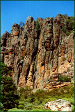
The spectacuarly rugged scenery of the Grampians National Park
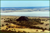
The view to Mitre Rock from atop
Mt Arapiles
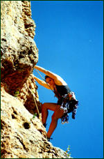
Scaling a face on the world renowned
Mt Arapiles |